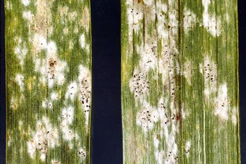
Wheat powdery mildew (WPM) is a destructive fungal disease that damages leaf tissues, weakens plant growth, and can cause severe yield losses or even crop failure. Current field diagnosis still relies heavily on expert visual inspection, which is labor-intensive, subjective, and difficult to scale.
Although hyperspectral remote sensing has shown promise for crop disease detection, many existing vegetation indices (VIs) were developed for general pigment, biomass, or stress monitoring rather than disease-specific pathogen–host responses. Machine-learning methods can also require large, high-quality training datasets. Due to these challenges, in-depth research is needed to develop a specific, stable, and scalable method for WPM detection from ground to unmanned aerial vehicle (UAV) scales.
Wheat powdery mildew index
A new study, published in Journal of Remote Sensing, addresses the need for rapid, field-scale monitoring of WPM in smallholder farms, where disease spread can be spatially uneven and difficult to capture through manual scouting alone.
The study developed two forms of wheat powdery mildew index (WPMI): WPMIG = (R760 − R554)/(R661 + R554) and WPMIR = (R760 − R661)/(R661 + R554). These indices were designed from disease-sensitive bands in the green, red, and near-infrared (NIR) regions. Compared with traditional VIs, WPMI more consistently distinguished healthy and infected wheat and better quantified disease index (DI) across leaf, ground canopy, and UAV canopy scales. WPMIG showed particularly strong performance and was selected for UAV-based hot-spot analysis to reveal potential infection and recovery areas.
MICROBIOLOGY ON TAP: Get full access to all The Microbiologist articles from just £2.17 a month
The researchers collected three years of data from greenhouse and field experiments conducted from 2022 to 2024. The dataset included 1,260 leaf spectra and 804 canopy spectra under different infection conditions, wheat varieties, and spatial scales. At the leaf scale, WPMI achieved the highest overall classification accuracy (OCA), reaching 85% and 86% for WPMIG and WPMIR, respectively, in the 2022 greenhouse experiment.
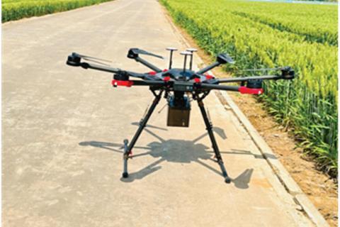
In field conditions, the two indices achieved 81% and 80% accuracy in 2023, and 80% and 81% in 2024. For disease severity estimation, WPMIG reached R² values of 0.55 to 0.93 at the ground scale and 0.48 to 0.90 at the UAV scale. The UAV-derived WPMIG maps, combined with Getis–Ord Gᵢ* hot-spot analysis, identified clusters of likely infection and tracked spatiotemporal changes across smallholder plots over three growing seasons.
The researchers noted that a disease-specific spectral index can move crop disease monitoring beyond simple image comparison. By linking UAV hyperspectral imagery with spatial hot-spot analysis, the method can help reveal where WPM is emerging, expanding, or declining, offering a potential basis for earlier warning and more targeted disease management.
Early warning system
With further validation across regions, wheat varieties, sensors, and disease conditions, WPMI-based UAV monitoring could support precision plant protection and early warning systems for wheat production.
The approach may help farmers identify disease hot spots before severe outbreaks occur, reduce unnecessary pesticide use, and improve field-level decision-making.
More broadly, this strategy provides a framework for developing disease-specific remote sensing indices for other crop–pathogen systems, contributing to smarter and more resilient agricultural monitoring.


No comments yet